
Tropical Storm #NandoPH (RAGASA)
TROPICAL STORM NANDO SLIGHTLY INTENSIFES AS IT MOVES OVER THE PHILIPPINE SEA.
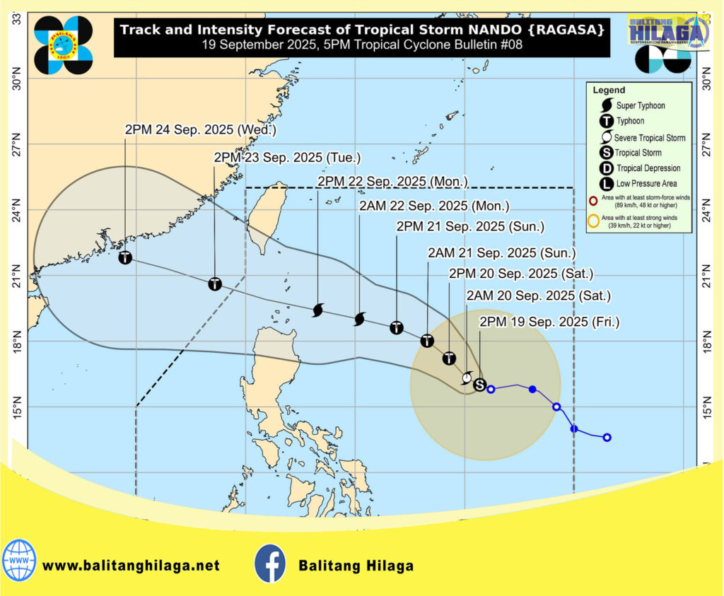
Location of Center (4:00 PM): The center of Tropical Storm NANDO was estimated based on all available data at 905 km East of Central Luzon (16.1°N, 130.6°E).
Intensity: Maximum sustained winds of 85 km/h near the center, gustiness of up to 105 km/h, and central pressure of 996 hPa
Present Movement: West northwestward at 10 km/h
Extent of Tropical Cyclone Winds: Strong to gale-force winds extend outwards up to 400 km from the center
TROPICAL CYCLONE WIND SIGNALS (TCWS) IN EFFECT
No Wind Signal currently hoisted.
OTHER HAZARDS AFFECTING LAND AREAS
Heavy Rainfall Outlook
Onset of heavy rains due to the Southwest Monsoon and NANDO is possible by Sunday (21 September).
Severe Winds
NANDO may enhance the Southwest Monsoon as it approaches the landmass. Wind Signal No. 1 will be hoisted over Northern Luzon tomorrow (20 September) morning, and the highest Wind Signal that may be hoisted throughout its passage is Wind Signal No. 5.
The Southwest Monsoon and the trough of NANDO will bring strong to gale-force gusts over the following areas (especially in coastal and upland areas exposed to winds):
• Tomorrow (20 September): Bicol Region, Eastern Visayas, and Caraga
• Sunday (21 September): CALABARZON, Bicol Region, Visayas, Northern Mindanao, and Caraga
HAZARDS AFFECTING COASTAL WATERS
24-Hour Sea Condition Outlook
In the next 24 hours, NANDO is unlikely to affect the sea condition. Moderate to rough seas is likely over most of the coastal waters of Luzon beginning tomorrow (20 September) evening. Increasing significant wave heights reaching up to 14.0 m is possible as NANDO approaches Extreme Northern Luzon.
Coastal Inundation
Storm surge warning may be raised over the coastal waters of Northern Luzon tomorrow.
TRACK AND INTENSITY OUTLOOK
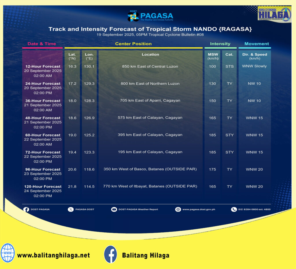
• NANDO is forecast to move generally northwestward until Saturday before turning west northwestward towards Extreme Northern Luzon. On the forecast track, the center of NANDO may pass close or may make landfall over Babuyan Islands between Monday (22 September) afternoon and Tuesday (23 September) early morning. It may exit the Philippine Area of Responsibility by Tuesday noon or afternoon.
• NANDO will continue to intensify while over the Philippine Sea. It may reach typhoon category tomorrow and super typhoon by Monday before its close approach to Babuyan Islands.
Considering these developments, the public and disaster risk reduction and management offices concerned are advised to take all necessary measures to protect life and property. Persons living in areas identified to be highly or very highly susceptible to these hazards are advised to follow evacuation and other instructions from local officials. For heavy rainfall warnings, thunderstorm/rainfall advisories, and other severe weather information specific to your area, please monitor products issued by your local PAGASA Regional Services Division.


